JPS is not responsible for domestic or industrial water supply. Please contact the relevant authorities such as Air Selangor.
Flash floods are floods that occur within a period of less than six (6) hours due to heavy rain, causing the existing drainage system to be unable to accommodate the high surface water flow.
Floods caused by monsoon drains and embankments fall under the responsibility of the Local Authority (PBT).
JPS WPKL is responsible for floods originating from the overflow of main rivers, namely the Klang River, Gombak River, Batu River, Jinjang River, Keroh River, Kerayong River, Kuyoh River, Midah River, Penchala River, and Kemunsing River.
We appreciate information about the reasons and causes of river pollution. However, JPS WPKL is not the enforcement authority for pollution control. Complaints regarding river pollution are referred to the Department of Environment (JAS).
Please refer to the relevant Local Authority (PBT) responsible for the maintenance of waste in the related drains.
If you witness squatters beginning to occupy the river reserve, leading to pollution and river contamination, you can immediately contact JPS WPKL. JPS will promptly liaise with the relevant authorities to relocate the squatters as quickly as possible.
Any complaints can be made through the Public Complaints Management System (SISPAA) accessed at
https://water.spab.gov.my/eApps/sdmscasepool/SdmsCasePool/add.do
The complaint is directed to the Local Authority (PBT). Section 50 of the Roads, Drains and Buildings Act 193 (Amendment Act A867) states that the Local Authority (PBT) is responsible for constructing and maintaining drains and water channels.
Any complaints can be made through the Public Complaints Management System (SISPAA) accessible at https://water.spab.gov.my/eApps/sdmscasepool/SdmsCasePool/add.do
The excavation works include removing sediment, deepening, eliminating any obstacles within the river, stabilizing riverbanks, and maintaining non-movable assets.
No. The enforcement of laws related to river pollution falls under relevant enforcement agencies such as the Department of Environment (Jabatan Alam Sekitar), Local Authorities (Pihak Berkuasa Tempatan), the National Water Services Commission (Suruhanjaya Perkhidmatan Air Negara - SPAN), State Water Regulatory Bodies, and District and Land Offices.
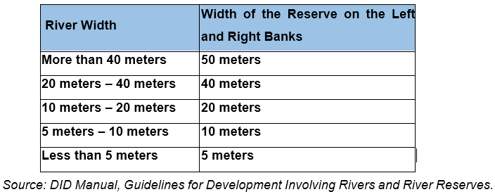
The width of the river reserve required by the Department of Irrigation and Drainage (Jabatan Pengairan Saliran - JPS) during the application for a particular lot depends on the existing width of the river.
In general, JPS does not encourage applications to use river reserves as they are flood plains exposed to river water level rises. Additionally, river reserves serve as spaces for river maintenance works.
However, we may consider specific applications on a case-by-case basis.
Applications for hydrological data are under the supervision of the Head Office, Water Resources and Hydrology Management Division, Department of Irrigation and Drainage Malaysia. The application can be submitted to:
Director,
Water Resources and Hydrology Management Division
Level 1, Block A,
Department of Irrigation and Drainage Malaysia
Persiaran Rimba Permai, Cyber 8,
63000 Cyberjaya, Selangor
(Attention: Information Management Unit)
Email: upm@water.gov.my and upm.bsah@gmail.com
All users are required to fill out the provided application form. Form DI.1 or Form DI.2 can be found in Word format for printing. After completing the form, users can fax it to the above address or send it via email. It is recommended that users refer to our inventory stations to determine the stations and data acquisition period during the form-filling process. Refer to the application procedures at http://rhn.water.gov.my/sprhn/utama/indexIn.cfm?link=contact.cfm
Please refer to the MyPublicInfobanjir application or the Public InfoBanjir website at http://publicinfobanjir.water.gov.my to view the current river levels in your location.


